First off, what an epic name for a mountain range… the Sentinels. The name is pretty apt too, as when they first come into view around the bend, you can’t help but say “wow” as I did the first time I saw it earlier this year.
I didn’t think I’d get a chance to climb them so soon again but when the idea was put forward to climb the Needles this weekend, I half jokingly suggested doing the Sentinels too. Gemma, being the awesome person she is said “yes and yes”. Whoop whoop, one day, two hikes, a fine plan indeed!
On the way there we kept a close eye on the weather as it was looking like things would take a turn for the precipitated by noon. The Sentinels was our first port of call and we got to the Wedge River picnic area at a perfect time. The morning mist was lifting and the sun was shining.
The first obstacle on the journey up was a river crossing, via a very slippery log. I got my log crossing strategy all wrong and almost lost my footing but eventually made it across. Seriously though, crossing a log in a river to get to the top of a mountain, is there anything better?
The next challenge was the swamp of treacherous mud. My low top hiking boots were not made for this so there were more than a few ginger footsteps taken through this section. Again though, much fun!
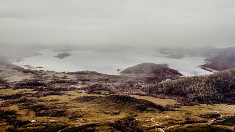
After crossing the swamp we made it out onto the flat plains at the base of the Sentinels. This whole area was devastated by fires recently and the landscape is charred and gutted. Trees have turned to charcoal and the soil is black and cracked. Some might think that would be awful but I loved it, such a fascinating scene. The signs of regrowth are thankfully there as fresh green shoots peak out above the blackened ground.
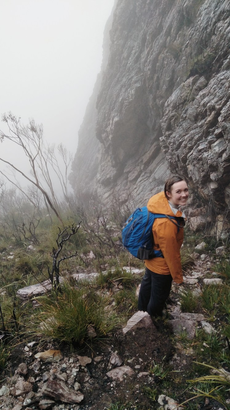
Before long we were beginning the proper ascent. Pink ribbons tied to the remaining trees mark the way and they’re a Godsend as finding a way up could be a bit dodgy otherwise. The way up is also marked by gravely pink stones so it’s pretty hard to get lost in reality.
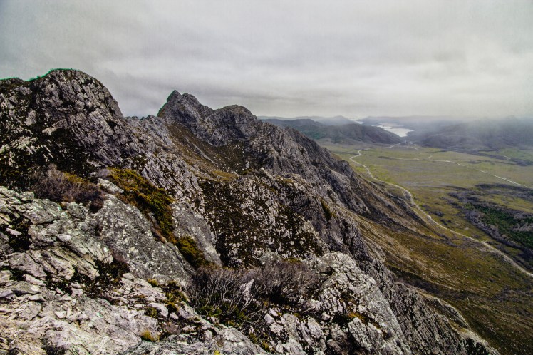
Soon enough we got to the real part of the climb, a narrow ridge line that runs along the base of one of the massive columns that make up the Sentinels. The climb to the top is fairly straightforward but certainly not the faint hearted. You’ll be thankful for the remaining trees and roots as they provide a comforting handhold on the steeper sections.
There’s a couple of rocky outcrops that call for a spot of clambering but nothing too taxing or requiring sherpas and a set of ropes. There’s always going to be the urge to turn around and take in the view as you climb but if it’s a clear day, don’t. Resist the urge, put on a blindfold….. actually no don’t do that.
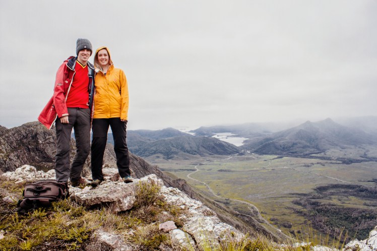
The view from the top is worth the wait if you can hold off from taking a peak on the way up. The weather closed in a little as we reached the summit (or at least one of them as there’s a few along the top ridge line) but the view was still amazing.
Now about that weather…..A few minutes after we had reached the summit and taken the obligatory selfies the rain reached us. It had been looking ominously from Lake Gordon on our way up and sure enough, it got us. The descent was a wee bit iffy and visibility dropped waaaay down. We couldn’t see the foot of the mountain, never mind the car park beyond the plains and swamp.
We made it back down though, our hands suitably refreshed from the charcoal off the trees. Having survived the climb and descent unscathed, I of course fell on my arse mere feet from the car! Thankfully not into the river or into a swamp bath.
Our plan of two hikes in one day alas had to be cut short. The Needles will just have to wait for another day. Can’t freaking wait!


Loving the tones in the photos (and the rest of the photos/post), I’ll need to explore this range!
Great photos James. I did this walk some years ago. The climb was a bit challenging for my knees. And as kids, we always referred to those shelters in the car park as the elephant huts because of their curved roofs.
.
It’s certainly a little arduous alright. My legs are rather stiff this morning, the good auld two days after the event pain 😊
Your enthusiasm and enjoyment of a tough outing is infectious. Well done. Regards Maurice
Thanks Maurice, it’s never tough when you have good company and spectacular views awaiting at the top.
GREAT pics! I found this range on a drive out to Lake Pedder, and I’ve been trying to arrange a return to get up there. Is there anywhere to camp up top that is relatively sheltered?
Hi Phil, I’m not sure about camping on the summit, it’s quite exposed. Best bet would be to camp down at the car park at the base and then go from there. There could be some sheltered spots on the far side that didn’t get burned but don’t take my word for it 🙂
I saw this for the first time a couple of weeks ago and my first reaction was also “wow” and my second thought was how do I get back here to get to the top. It looks amazing!
I can’t wait to get back there either, definitely the funnest climb so far. Will hopefully get better weather too
Thanks for great pics Walked to Lake Pedder before flooded from a bit further on from Sentinels over the Coronets
Nice! That must have been amazing back in the day with the pink beach.